Quick facts
An off-the-beaten-path Annapurna loop through remote Gurung villages and alpine ridges to Khopra Danda, with an optional side trip to the sacred Khayer Lake at 4,500m.
Overview
Khopra Ridge is the route I suggest when someone has already done Poon Hill and wants the next level of quiet. The trail shares some of the same forest terrain — you will walk through rhododendron and oak that rivals anything on the Ghorepani route — but beyond Tadapani it peels away from the main trekking corridor and climbs to a secondary ridge system that few visitors bother to find. The result is a genuine sense of remoteness in a region most people assume is fully developed.
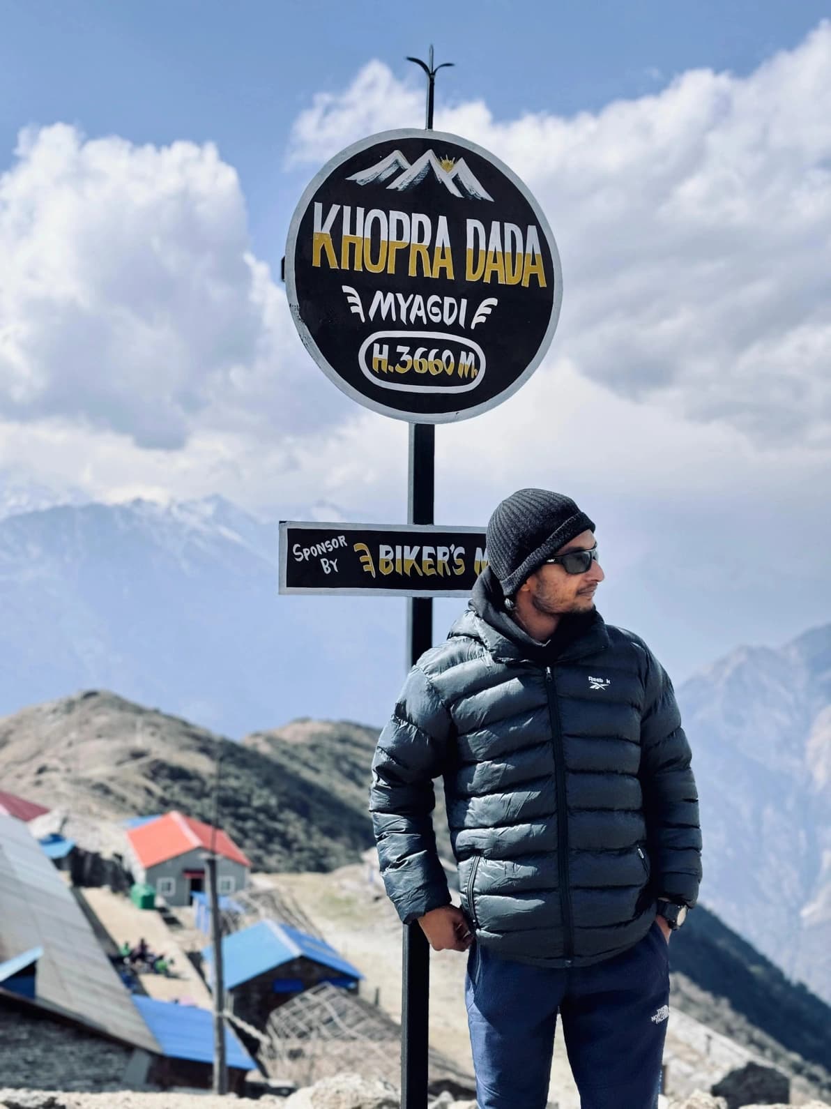
The ridge itself, Khopra Danda at 3,660m, gives a different perspective on the Annapurna massif than Poon Hill does. You are looking at Annapurna South and Machhapuchhre from a position further east and at a slightly different angle, with Dhaulagiri anchoring the western horizon. The sunrises here are unhurried — no crowd on the platform, no timer on the experience. The teahouses on Khopra Ridge are community-owned and the income flows directly to the villages below, which I appreciate and try to support.
For those who want an extension, Khayer Lake (also written Khair Lake or Khopra Lake) at 4,500m is a sacred alpine tarn tucked below the Annapurna South massif. The side trip adds a day and pushes well above the standard sleeping altitude, so I reserve it for trekkers who are acclimatising well and have expressed interest before we start. The combination of the ridge camp and the lake makes for one of the most complete Annapurna experiences available in 6-7 days.
Who this trek is for
Khopra Ridge suits trekkers who have already experienced Poon Hill or similar routes and want something that feels more exploratory. The sleeping altitude peaks at 3,660m — higher than Ghorepani but still manageable for most adults with good baseline fitness. The optional Khayer Lake extension at 4,500m makes it suitable for those with altitude experience who want to push further. Not the right route for complete beginners or anyone with significant altitude sensitivity.
Best views & moments
- Khopra Danda ridge sunrise with Annapurna South, Machhapuchhre, and Dhaulagiri in a single frame
- Optional trek to Khayer Lake at 4,500m — a sacred alpine tarn at the base of the Annapurna massif
- Community-owned teahouses on the ridge where the profits stay in the valley villages below
- Remote Gurung and Magar villages of Swanta and Dobato with virtually no other trekkers
- Mulde Viewpoint at 4,310m — one of the most panoramic spots in the entire Annapurna region
- Dense rhododendron forest between Ghandruk and Tadapani rivalling anything on the Poon Hill trail
Day-by-day itinerary
Route & terrain
The Khopra Ridge route begins in familiar Annapurna territory — Nayapul, the Modi Khola valley, and the climb to Ghandruk — before departing from the well-trodden corridor. From Tadapani the trail joins the Khopra ridge system heading east and north-east, climbing into progressively quieter terrain through secondary rhododendron and conifer forest.
Above Chistibung the vegetation begins to thin and the ridge character of the route becomes apparent. Dobato at 3,420m marks the transition above the tree line, where the path runs along an exposed spur with the Annapurna massif dominating the northern skyline. The optional detour to Mulde Viewpoint at 4,310m is a significant day extension but reveals one of the most complete panoramas in the region — Annapurna range from I through South, Machhapuchhre, Dhaulagiri, and dozens of lesser peaks in a single sweep.
Khopra Ridge (3,660m) is the main camping and viewpoint elevation, home to community-run guesthouses funded by the ridge eco-project. The optional side trip to Khayer Lake climbs steeply on a rocky trail from the ridge camp, gaining 840m to reach the tarn at 4,500m. The lake sits in a glacially carved bowl below the southern face of Annapurna South. The descent from Khopra runs south to Swanta village and then traverses back to the main Annapurna trail at Ghorepani, allowing a final optional Poon Hill sunrise before the finish at Nayapul.
General info
Difficulty & preparation
Khopra Ridge is a genuine moderate trek — harder than Poon Hill, more demanding than a typical Annapurna foothills walk, but not in the same category as Manaslu Circuit or the upper Annapurna routes. The difficulty is a combination of higher sleeping altitude (3,660m), longer days on the upper section, and trail quality that becomes rougher above Chistibung.
The Dobato-to-Khopra section on day four involves the most sustained climbing of the route — 5-7 hours if you include the Mulde Viewpoint detour, with significant sections on loose rocky trail above the tree line. Trail-finding here requires more attention than on the main Annapurna routes, and the path becomes genuinely exposed on the ridge itself. Good trekking boots, not trail runners, are appropriate.
The optional Khayer Lake extension at 4,500m pushes into territory where acclimatisation matters. Day tripping from a 3,660m sleep to 4,500m and back is within the acceptable range, but it requires that you are feeling well at Khopra Ridge with no headache or fatigue. I make that call on the morning based on each person's condition rather than in advance.
Weather is a more significant factor here than on the main trails. The Khopra Ridge is exposed and can be wind-affected even in fine seasons. Afternoon cloud builds quickly; I time ridge days for morning. The route is less well-maintained than the main Annapurna corridors, which means muddy sections in rain and some tricky navigation in cloud.
How to prepare
Khopra Ridge demands a step up in preparation compared to Poon Hill. Six to eight weeks of consistent aerobic training is appropriate — the ridge section involves a 3,420-3,660m sleeping altitude range that puts real demands on the cardiorespiratory system, and tired legs on the Dobato section are a real risk for underprepared trekkers.
Building specifically for sustained uphill walking is the priority: loaded pack walks on inclines, stair work, hiking with elevation gain. If you have trekked to 3,000m+ before and handled it well, Khopra is a natural next step. If you have not been above 2,500m, some altitude acclimatisation in Nepal before starting (a day or two in Pokhara at 822m is not enough — spending a day around 2,000-2,500m first would help) makes sense.
For the Khayer Lake extension specifically, previous experience above 4,000m is strongly preferable. I do not recommend it to anyone without some high-altitude trekking background unless they acclimatise exceptionally well on the lower days.
Permits you'll need
Annapurna Conservation Area Permit (ACAP)
NPR 3,000 (~USD 22) for foreigners; NPR 1,000 for SAARC nationals
Required for the entire Khopra Ridge route. Obtainable at the ACAP counter in Pokhara (Damside) or the Nepal Tourism Board in Kathmandu.
TIMS Card (Trekkers' Information Management System)
NPR 1,000 (~USD 7) when trekking with a registered agency; NPR 2,000 independently
Mandatory for all trekkers in the Annapurna region. The Khopra community guesthouses also levy a small community conservation fee (approximately NPR 200-500) at the ridge camp.
I handle all permit paperwork as your licensed guide.
Altitude & acclimatisation
Sleeping altitude on Khopra Ridge peaks at 3,660m at the ridge camp, making this a moderate altitude trek with a real acclimatisation requirement. The ascent profile from Ghandruk (1,940m) to Khopra Ridge (3,660m) over three nights gains approximately 1,720m of sleeping altitude — an aggressive profile that benefits from the optional acclimatisation night at Dobato (3,420m) before moving to the ridge.
AMS symptoms at 3,660m are more common than at the Poon Hill sleeping altitude of 2,874m. Mild headache, reduced appetite, and fatigue on the first night at Khopra are fairly normal and usually resolve overnight. Persistent or worsening symptoms the following morning are the signal to descend rather than proceed to Khayer Lake. I carry supplemental oxygen as a precaution and am experienced in recognising the difference between normal acclimatisation discomfort and genuine AMS progression.
The Khayer Lake extension reaches 4,500m — the highest point on this itinerary — on a day excursion from the 3,660m camp. The body is well-adapted to the sleeping altitude by then, and ascending 840m during the day rather than sleeping at that altitude is a sensible approach. Nonetheless, headache and reduced performance at 4,500m are common. Drink steadily, go slowly, and watch for any deterioration on the lake trail.
Food & accommodation
Ghandruk and Tadapani have well-established teahouses with good food, hot showers, and reasonable comfort. Above Tadapani the infrastructure becomes more basic — Chistibung and Dobato have smaller guesthouses that are clean but simple, with limited menu options. The community guesthouses on Khopra Ridge are a genuine highlight: simple, warm, and staffed by people from the villages below who take real pride in the place. The food — dal bhat, garlic soup, noodles, Tibetan bread — is better than the location suggests.
Swanta village on the descent has friendly local guesthouses that are rarely full and where the family cooking often beats the more tourist-facing establishments on the main route. Budget for meals increasing with altitude; at Khopra Ridge a standard dal bhat will cost NPR 800-1,000 compared to NPR 400-500 at Ghandruk. Carry all cash from Pokhara.
What to pack
The ridge section of Khopra requires more serious gear than Poon Hill. Temperatures at Khopra Ridge (3,660m) drop to -10°C or below on clear winter nights and to near freezing in the spring and autumn windows on cold nights. A sleeping bag rated to at least -10°C or a good -5°C bag plus liner is necessary. Teahouse blankets are available but supplementary, not sufficient on their own at this elevation.
Warm insulation layers are more important here than on any of the lower Annapurna routes. A down jacket or synthetic insulated jacket, thermal base layers, and a reliable wind and waterproof shell. Waterproof gaiters are useful for the muddy forested section between Tadapani and Chistibung in wet conditions.
For the Khayer Lake extension, bring sunscreen rated SPF 50+ and UV-blocking sunglasses — the UV intensity at 4,500m is significant and the tarn is at high elevation with no shade. Trekking poles are non-negotiable for the steep descent from the lake back to Khopra Ridge. A small thermos of hot water for the lake excursion is a good idea — the body needs fluids and the morning starts cold.