Quick facts
A quiet community ridge walk south of the Annapurna massif, crossing hill settlements in Kaski or Parbat district with open Dhaulagiri and Annapurna views and almost no trekking traffic.
Overview
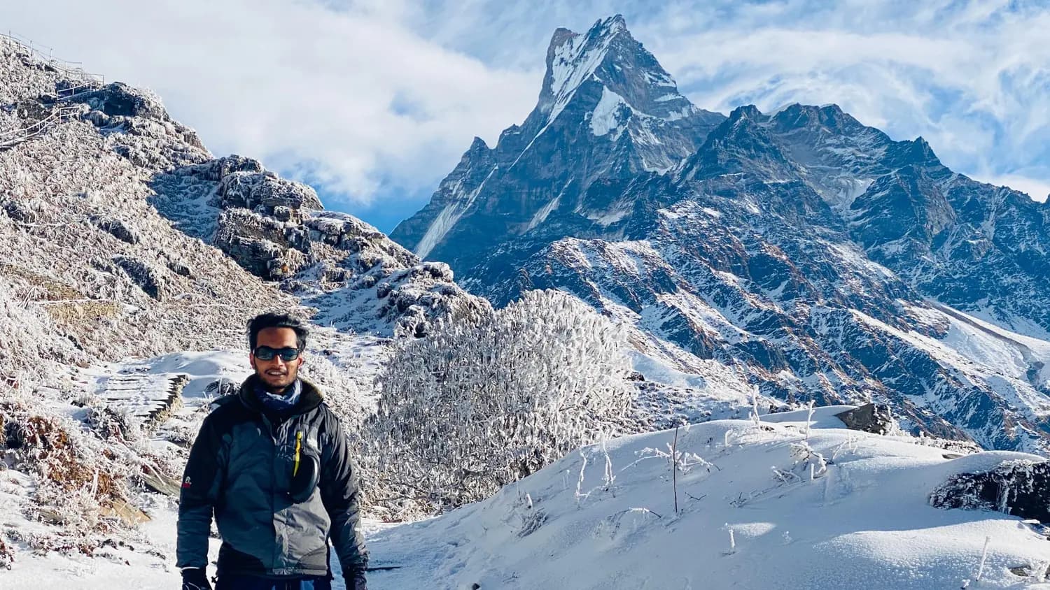
The Marche Trek is one of those routes that does not show up in any guidebook under that name. It is a local name for a community trail I use with clients who want a short, lower-altitude walk through the hills between Pokhara and the Parbat district — terrain that is deeply familiar to me but essentially invisible to mainstream trekking itineraries. The trail threads through agricultural terraces and small settlements, crossing a ridge that offers a clean west-facing panorama of Dhaulagiri and the southern Annapurna wall.
Because this is not a commercialised route, the infrastructure is minimal. Accommodation is in local homestays or simple lodges, and meals are whatever the household is cooking that day — usually dal bhat with seasonal vegetables. There are no signs, no tea-stall clusters, and no other trekking groups. What you get instead is a sense of what walking in this part of Nepal was like before the main routes became well-worn tourist corridors.
I should be honest: very little about the Marche Trek is documented online, and the exact routing and stopping points flex depending on the season, which homestays are open, and what my clients are looking for. I treat this as a flexible three-to-four-day walk rather than a fixed itinerary. If you are interested, get in touch and I will walk you through exactly what the route looks like for your dates.
Who this trek is for
Trekkers with limited time who want genuine hill walking without the commercial atmosphere of Poon Hill or Mardi Himal. Good for people staying in Pokhara for a few days who want one short trek before or after a longer trip. Note: the Marche Trek has minimal online documentation and I have not seen it described in any English-language guidebook under this name — itinerary and stopping points are flexible and confirmed with me directly before departure.
Best views & moments
- Panoramic views of Dhaulagiri (8,167m) and the southern Annapurna flank from the main ridge
- No trekking crowds — genuine off-the-beaten-path experience in the Pokhara hinterland
- Village life in Kaski or Parbat district far from tourist infrastructure
- Rhododendron and oak forest on the upper ridge sections
- Flexible pace and itinerary matched to the group rather than a fixed commercial schedule
Day-by-day itinerary
Route & terrain
The route starts from a roadhead south or southwest of Pokhara accessible by jeep, climbs through lower hill farmland, and gains the main ridge separating Kaski from Parbat district. The high point is approximately 3,100m. The ridge gives broad views west to Dhaulagiri and northwest to the Annapurna range. Descent is via the approach valley or a secondary track to a different roadhead. The exact route is not mapped commercially and is navigated with local knowledge. A licensed guide is required for foreign trekkers under Nepal's 2023 regulation and is practically necessary here given the absence of trail signage.
General info
Difficulty & preparation
Rated Easy-Moderate. The ridge sections involve some sustained climbing over two to three hours, but maximum altitude is around 3,100m and there are no technical sections or steep exposed traverses. The main physical demand is the daily walking time — five to seven hours with moderate elevation gain. Anyone who walks regularly and has basic hill fitness can manage this route comfortably. The descent can be steep in places and is slippery in wet conditions.
How to prepare
No specific preparation beyond general fitness is required. If you are accustomed to multi-hour walks with some uphill, this route will be well within your range. Bring broken-in footwear with good grip — the trail surfaces are uneven and can be muddy. Trekking poles are helpful on the descent. I handle all logistics including transport and homestay arrangements — there is nothing to pre-book independently.
Permits you'll need
Annapurna Conservation Area Permit (ACAP)
NPR 3,000 (foreigners) / NPR 1,000 (SAARC nationals)
Required if the route enters the Annapurna Conservation Area boundary, which is likely for the upper ridge sections. Confirm with me when booking — the exact boundary relative to this route needs to be verified for your specific itinerary.
TIMS Card
NPR 1,000 (with registered guide/agency) / NPR 2,000 (individual)
Standard TIMS card required for all trekking routes.
I handle all permit paperwork as your licensed guide.
Altitude & acclimatisation
Maximum altitude is approximately 3,100m. AMS risk at this altitude is low for most healthy trekkers, particularly because the route ascends gradually over two days rather than rapidly. Mild headaches are possible on the high ridge section for people who are not acclimatised from a prior trek. Descend if symptoms worsen. No rest days for acclimatisation are needed at this altitude range.
Food & accommodation
All accommodation is in local homestays — basic rooms, shared toilet facilities, no hot showers. Meals are home-cooked Nepali food: dal bhat, seasonal vegetables, eggs, and tea. There are no teahouses or restaurants in the commercial trekking sense. I arrange homestays in advance where possible but occasionally we confirm on arrival. This is part of the authentic experience on this route and also its main logistical limitation — it requires trust that the arrangements will hold, which is why going with a local guide who knows the households matters.
What to pack
The altitude range means temperature can vary significantly between the valley floor and the ridge. A light insulating layer and a waterproof shell are enough for spring and autumn. At the high point in autumn evenings, temperatures drop to single figures — bring a warm hat and gloves. A daypack is sufficient if I carry the heavier gear or arrange a porter. Carry cash in Nepali rupees; no ATMs or card payment anywhere along this route.